Report of Field Survey Results
Searching
for any sign of HM Ships Erebus and Terror has been at the forefront of many expeditions over
the last 150 years. Yet, while
lying at the heart of the Franklin Expedition’s failure to navigate the elusive
North-West Passage, the ultimate circumstances surrounding the ships’ loss
remains a mystery.
Public interest in what is known of
the Franklin disaster is reflected in the designation of Sir John Franklin as a
Person of National Historic Significance, along with two related National
Historic Sites (NHS) in Nunavut (the Beechey Island NHS, and the Erebus and
Terror NHS, Erebus Bay). While
historical research is unlikely to offer much new information, archaeological
research has a demonstrated potential to yield exciting data with a clear
benefit to public education. For
example, the Franklin graves at Beechey Island NHS have been subject to
detailed archaeological investigations by Owen Beattie and his colleagues with
interesting and well-publicized results (Beattie and Geiger 1987). Just as terrestrial cultural resources
in the Arctic may be remarkably well preserved and rich in scientific data, so
submerged cultural resources in the isolated underwater environment of the
Arctic may be exceptionally rich in material for scientific research and public
education.
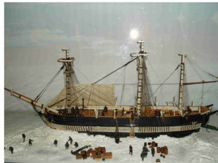
Both Erebus and Terror were converted Royal Navy bomb vessels. They represent a type of ship type that made a critical
contribution to polar exploration over the span of a century, between 1741 and
1845. The “bombs” were robustly
built in order to mount heavy mortars used to bombard coastal installations and
port cities. Vulnerable to attack
by other ships, they tended to use the cover of night to move within range of
the their targets. The Royal Navy
bombs were typically named after volcanoes (eg: Hecla, Aetna,
Vesuvius), or denizens of a fiery
underworld (Beelzebub, Fury, Erebus) alluding to their appearance at night as they
blasted their mortar bombs, and incendiary “carcasses” into a high
trajectory. The choice of name
also underlined their usefulness as weapons of psychological terror. While the bombs’ indifferent sailing
qualities and minimal accommodation space made them poor cruisers in the years
between wars, with their mortars and magazines removed, their hefty scantlings
made them the best of the larger ships used for polar exploration. They became the vessel type preferred
by Middleton, Parry, Back, and Ross for exploring north and south polar seas,
just as converted Whitby colliers of similar size were preferred by Cook and
Vancouver for contemporary explorations in the Pacific. No bomb vessel has survived. Three of the eight Royal Navy bombs
used in polar exploration were wrecked in that capacity, all in the Canadian
Arctic. HMS Fury was ground to a pulp by the ice over the rocks of
the Somerset Island beach that bears its name. And one ship, either HMS Terror or Erebus,
was probably crushed in the ice off Cape Frances Crozier, its remains scattered
beneath a permanently advancing cover of ice. If the other of Franklin’s two vessels survived long enough
to sink in relatively benign circumstances off Utjulik, it would provide a
unique archaeological opportunity to study a type of vessel that had
contributed so much to polar exploration in the age of sail. Both Terror and Erebus are of additional interest because they employed some cutting edge
technology for the period, including built-in water tanks, diagonal iron
bracing (Erebus), central heating
systems,
ice-reinforced bows,
and auxiliary screw propulsion (Fig. 3).
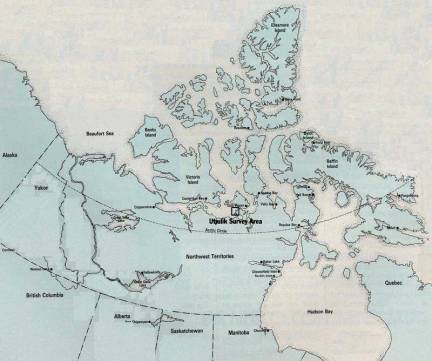
The
search areas for this project were defined by Woodman and are based on
intelligence gleaned from the Inuit first by Leopold McClintock in 1859, later
by Charles Frances Hall, and with greatest detail by the Schwatka expedition in
1879 (Woodman 1991: 248-269; 2003).
The interpretation Woodman presents is that one of the two vessels in
the Franklin expedition survived a minimum of three winters in the pack ice of
Victoria Strait, before being finally released into the Queen Maud Gulf. Probably under the direction of a
skeleton crew by this time, it was maneuvered to, and perhaps anchored at, the
location where it was ultimately observed by the Neitchille Inuit in smooth
year-ice near an island off the north-west shore of the Adelaide Peninsula
(Utjulik). It sank there with a
minimum of violence, possibly the result of a botched salvage attempt, in water
sufficiently shallow that the tops of the masts were visible (suggesting a
depth of less than 130 ft./40m). There is some ambiguity in the accounts
suggesting either that this location was off Grant Point (northern search area)
or the island currently identified as O’Reilly Island (southern search
area). The total search area
represents some 300km2.
Captain
Woodman began his investigations in these areas in 1992 with an airborne
magnetometer search that identified 61 magnetic anomalies (Woodman 1992). The most promising of these three targets
were investigated in 1993 with through-ice sidescan sonar, but without
result. Sea-borne surveys in 1997
and 2000 employed side-scan and forward-looking sonar as well as magnetometer,
but due to wind and seas over the short summer seasons only about 80km2
were covered (Woodman 1997; Bertulli 1998; Grenier and Harris 2004; Delgado
2000). In contrast, 11 days of sled-borne
magnetometer work in 2001 covered all of the Grant Point survey area,
approximately 166km2, with a line spacing of 200m (Woodman 2001). In 2002, a second sled-borne
magnetometer survey produced a higher resolution (50m) pattern in the vicinity
of targets identified in the previous year and surveyed at a 200m-spacing the
O’Reilly Island search area (Woodman 2002).
The surveys by boat and through the
ice confirmed that the underwater environment was generally a featureless plain
averaging 72 ft. (22m) in depth in the northern search area and 89 ft. (27m) in
the southern area. Notably absent were any signs of ice
scour on the seabed. This welcome
news meant that a wreck site located here might avoid impact by heavy ice,
raising the possibility that the local environment could potentially preserve a
wreck in a condition similar to the Breadalbane (1853) that was found largely intact and upright with two masts still
standing in about 300 ft. (100m) of water off Beechey Island (MacInnes 1985).
Over
a decade of searching off Utjulik all of the high priority magnetometer targets
identified in 1992 were found to be geological in origin. Others have been identified and
analysis of the accumulated magnetometer data prior to the 2004 season
identified three high priority targets remaining in the Grant Point search area
and four off. O’Reilly Island. The
2004 expedition would focus on these targets.
The approach to investigating the
magnetometer targets was to begin with relocating each target by GPS. At each location, a 16cm hole was to be
drilled allowing for an echo sounder and a sonar unit
to be lowered through. These
preliminary sensors would provide an idea of the depth, general bottom
topography and indications of a potential wreck site. If the preliminary results were positive the intention was
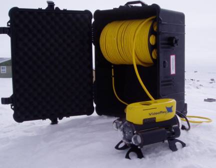
to cut a slightly larger hole to allow for the lowering of an ROV
mounting a camera and a sonar unit (Fig. 4). It was suggested in the permit application the ROV might be
the primary tool for the project.
If the ROV in turn produced positive sonar and visual results then the
next level of investigation would be by divers on SCUBA through a substantially
enlarged hole through the ice.
The potential of diving on an
archaeological site complicated the permitting process. Although there was never any intention
to collect artifacts or samples from the site, according to Nunavut Site
Regulations, a Class 2 permit is required for diving operations approaching
within 30m of a site. It would be necessary to approach
within this distance to visually confirm sonar results and undertake any site
identification or assessment.
Because of the proposed diving operations and the recognized
significance of the site (Henderson 1994; and see Appendix A), 17
project-specific conditions had to be met as a requirement of permit issuance,
including staying 3 metres away from any submerged cultural feature or site
(see Appendix B). Research
objectives were effectively limited to search and site identification, and
restrained production of documentary footage.
The only other shipwreck incident
reported in the area is a barge that sank in 1926 to the west of O’Reilly
Island (Woodman 2003: 8). Although probably an old sailing
vessel, identifying the remains of this barge in contrast to a bomb vessel
should be straightforward with visual access. It is generally thought that because Terror and Erebus were ships of the same type they were, therefore, practically
identical, especially after their refits for polar service. This would make identification between
these two vessels difficult. Terror was laid down to the Vesuvius Class specifications in 1812, while Erebus
was launched in 1826 to the Hecla Class specifications of 1813. One difference between classes was the
smaller as-built dimensions of the Vesuvius group, leaving Terror with about 1.83 ft. (0.56m) less breadth and 2.67
ft. (0.81m) less length than Erebus (Ware
1994:67-68). Easier to determine
from a survey required to stay 3 metres away from the wreck were a number of
diagnostic characteristics that may be discerned from two sets of as-fitted
plans. One set is labeled “Terror
and Erebus” (which adds to the perception that the ships are
indistinguishable), however, these 1839 plans are actually of Erebus, as several notes and sketched features indicate
different arrangements on Terror. On the other hand, the set of 1837 (as
fitted for 1836 with 1845 modifications for power drawn over) plans attributed
to Terror are certainly of that
vessel, and reveal a number of readily distinguished features from the 1839
plan set.
Diagnostic features based on
comparison of the two as-fitted plan sets that might be useful in identifying
the two vessels in a survey relying on distant visual data include 22
characteristics visible on deck.
For example, quarterdeck housings, pump type, number and location, fore
hatch locations, types of waist bulwark, davit and knight placements are quite
distinctive. There are also seven
topside characteristics visible, most conspicuously the continuous channel
blister found on Erebus. If the wreck were opened up, another
seven diagnostic characteristics are apparent from the lower, orlop, and hold
levels, including location and types of furnace and water tank
arrangements. Even if only the
major timbers remain, five diagnostic characteristics related to scantlings
including the angle of the sternpost to keel, and the 2 pair of futtock riders
installed only on the Terror, may
be identifiable (see Appendix C).
In the course of fieldwork, no
vessel or debris was found and no identification was necessary. In fact, no diving operations were
undertaken, whether with ROV or divers, to provide any visual data. Given the minimal bathymetric relief,
multiple hole coverage around each target, and quality of accoustic data from
each hole, it was determined that results from the through-ice sonar survey
were adequate to establish with reasonable certainty that no wreckage was
present on the seabed in the vicinity of the magnetometer target locations
investigated. Geological sources
for the magnetic anomalies may be assumed, and at some target locations minor
geological features were visible at or very near the datum. The through-ice sector sonar results
were also judged sufficient so that no additional detailed magnetometer work
was performed on this expedition.
Field
work took place between May 11 and May 21. The entire survey area was covered in ice measuring
approximately 2 meters thick.
Target areas were accessed by snowmobiles towing sleds. No survey days were lost due to
weather. Daytime temperatures
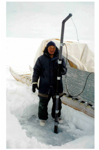
ranged from –20C to 4C with winds generally moderate. Auger holes drilled through the ice were 16cm in diameter,
which were large enough to take the sounding lead as well as the sonar housing
mounted on the end of a PVC pipe extension (Fig. 5).
Seven magnetometer targets were
classified as “priority one” based on the magnetic characteristics exhibited
(see Appendices D and E). These,
along with an additional eight targets of lower priority but all within the
specified search areas, were investigated. Four of the total number of targets proved to be located in
shallow water, less than 30 ft. (9.1m), so investigations at these locations
were limited to taking soundings.
All 15 of the magnetometer targets were located and holes cut through
the ice to take soundings between May 11 and 13. No sonar data was collected prior to the arrival of the
archaeologists (May 15).
The
typical procedure for investigation around a magnetometer target in a suitable depth
was to auger a hole at the centre of the anomaly. This location would become the datum for each search
pattern, with four additional holes typically being set out from the datum at a
distance of 100m along the four principal cardinal points, due north, east,
south, and west, respectively. For
some areas of less interest fewer holes were used.
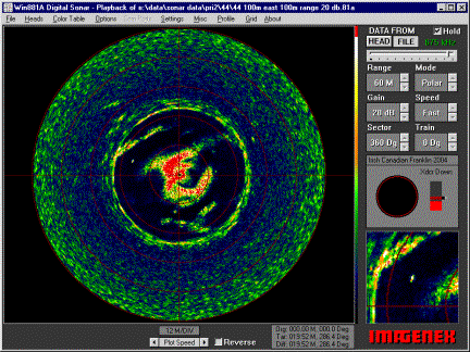
Sonar data was collected at various
range settings between 30 and 200 metres from each location into which the
sonar transducer was lowered. If anything of potential interest
showed in close proximity to the sensor location, an additional survey hole,
typically 50m distant, might be drilled.
Data
collection in the search areas consisted solely of through-ice sonar readings
and hand soundings taken from each hole with a line measuring 80 ft. (24.5m) in
length. Depths in excess of this
were estimated from sonar readings. Magnetometer targets in the northern
area were searched first. The
through-ice sonar data were entirely negative with respect to indications of
cultural material and were considered of sufficient quality in terms of
technology, methodology, and bottom conditions so that no efforts were taken in
deploying other search tools.
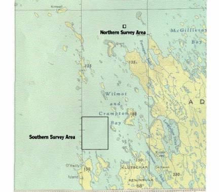
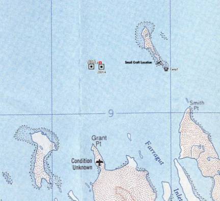
Three magnetometer targets were investigated off Grant Point
(see Figures 2 and 6). Around
these targets a total of 14 holes were drilled through the ice with soundings
ranging from 70 to about 90 feet (23 – 29m) in depth (see Table 1 for summary). The digital multi-imaging sonar
indicated a relatively flat bottom marked by a series of low relief ridges
running in a roughly NW/SE orientation, and nothing suggestive of ship remains.
Pattern 4
Dates Surveyed: May 16 and 17.
Test hole locations and water depths: Datum (P4), N
68.46574 W 98.65726, 74 ft. (22.6m); 100m north of datum (P4-1), 73 ft.
(22.3m); 100m south of datum (P4-2), 73 ft. (22.3m); 50m south of datum (P4-3),
73 ft. (22.3m); 200m south of datum (P4-4), 75 ft. (22.9m); 100m east of datum
(P4-5), 70 ft. (21.3m); 100m west of datum (P4-6), 73 ft. (22.3m).
The
bottom at this location exhibited ridges consistent in character and direction
with the geological trends on nearby land, although with a relief over seven
holes up to 300m apart of only 5 ft. (1.5m).
Extra
holes were drilled to the south of the datum at 50 and 200m distances because
there were apparently “hard” targets showing up in the water column beneath the
sonar head. These were not visible
in overlapping scans from other holes at various distances and were taken to
represent distortion or reflection from ice surface.
A
“diablo” unit was
dropped through datum hole in the hopes that it would serve as a control point
or datum for mosaicking the various sonar images around a target. It was not found to reflect sonar
effectively and was not used for this purpose after the Pattern 4 target area
was investigated.
An
experiment was tried at this target by lowering the sonar head to greater depth
suspended on its cable. Without
the PVC pipe to hold the unit steady it was too unstable to deliver useful
images. The camera was also
lowered as far as its cable allowed.
The bottom of the ice was found to be smooth with good visibility at the
ice-water interface, but no distinct images were discerned from a maximum depth
of about 45 ft. (13.75m).
N-2
Date Surveyed: May 17.
Test hole locations and water depths: Datum (N2), N
68.46326 W 98.6557, 78 ft. (23.8m); 100m north-east of datum (N2-1), 76 ft.
(23.2m); 100m south of datum (N2-2), 75 ft. (22.9m); approximately 100m
north-west of N-2 datum and precisely 200m south of Pattern 4 datum (P4-4), 75
ft. (22.9m).
N-3
Dates Surveyed: May 17 and 18.
Test hole locations and water depths: Datum (N3), N
68.46378 W 98.67628; 100m north of datum (N2-1); 100m south-east of datum
(N2-2); 100m south-west of datum (N2-3).
Sonar indicated depths of about 27m.
Sonar images showed some
particularly strong and straight ridge lines through N-2 and N-3, but relief
was still minimal and nothing of cultural interest was evident.
Table1: Magnetometer targets investigated in the
northern (Grant Point) search area. Priority assessment was based on magnetic
characteristics.
|
Target Name
|
Priority
|
Latitude
|
Longitude
|
Number of test holes
|
Ave. Water Depth
(Ft.)
|
|
Pattern 4
|
1
|
68.46574
|
-98.65726
|
6
|
|
|
N-2
|
1
|
68.46326
|
-98.65565
|
4
|
76.8
|
|
N-3
|
1
|
68.46378
|
-98.67628
|
4
|
+/- 90
|
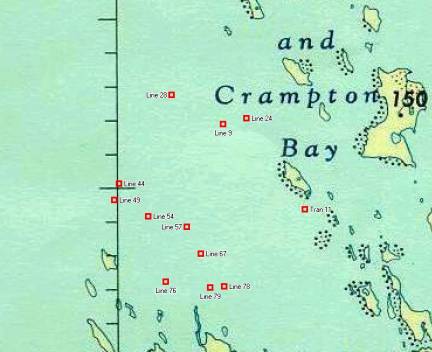
Twelve
magnetometer targets were investigated in the southern area (see Figures 2 and
7), where an additional 45 holes were drilled with soundings ranging from 6 to
about 170 feet (2 – 55m) in depth (see Table 2 for summary). Where the depths were greater than 30
ft. (9m), the approximate depth of the Erebus from keel bottom to gunwale top, the sonar unit was deployed. Images taken from 39 holes in eight
target areas showed stones and small boulders on a relatively flat bottom
marked by ridges similar to those noted farther north, but nothing suggestive
of ship remains.
Line 28
Date Surveyed: May 19.
Test hole locations and water depths: Datum (L28) N
68.21355, W 98.92705; 100m north of datum
(L28-1); 100m east of datum (L28-3); 100m south of datum (L28-2); 100m west of
datum (L28-4). Sonar indicated
depths of about 52m.
Line 9
Date Surveyed: May 19.
Test hole locations and water depths: Datum (L9) N 68.19893 N 98.85873, 78 ft. (23.8m); 100m
north of datum (L9-1), 70 ft. (21.3m); 100m east of datum (L9-3), 71 ft.
(21.6m); 100m south of datum (L9-2), 84 ft. (25.6m); 100m west of datum (L9-4),
83 ft. (25.3m).
Sonar
images still show strong ridge lines.
Strong returns from the occasional boulder were also evident.
Line 57
Date Surveyed: May 19.
Test hole locations and water depths: Datum (L57) N
68.14829 W 98.90721, 63
ft. (19.2m); 100m north of datum (L57-1), 66 ft.(20.1m); 100m east of datum
(L57-3), 70 ft. (21.3m); 100m south of datum (L57-2), 61 ft. (18.6m); 100m west
of datum (L57-4), 63 ft. (19.2m).
While sonar images in the
southern area continued generally to show the ridge lines trending to the
north-west, there are two exceptions in this target area where the alignment
differs over a distance of 30 and 60 meters respectively. Apart from this alignment, these
anomalies were consistent with the usual gravel ridges in respect to type and
pattern of return, and lack of shadow.
Line 44
Date Surveyed: May 20.
Test hole locations and water depths: Datum (L44) N
68.16982 W 98.99754;
100m north of datum (L44-1); 100m east of datum (L44-3); 100m south of datum
(L44-2); 100m west of datum (L44-4).
Sonar indicated depths between 23 and 26 metres.
One
strong isolated return in this area might be a 45-gallon drum (Fig. 8).
Line 49
Date Surveyed: May 20.
Test hole locations and water depths: Datum (L49) N
68.16168 W 99.00360; 100m north of
datum (L49-1); 100m east of datum (L49-3). Sonar indicated depths between 34 and 44m. Due to depth, only three holes were
drilled.
This target was outside the search area
as defined by Inuit testimony and was added to the survey as a “supplementary”
target due solely to its magnetometer priority.
Line 54
Date Surveyed: May 20.
Test hole locations and water depths: Datum (L54) N 68.15341 W 98.95873, 70 ft.
(21.3m); 100m north of datum (L54-1), 80 ft. (24.4m); 100m east of datum
(L54-3), 76 ft. (23.2m); 100m south of datum (L54-2), 76 ft.(23.2m); 100m west
of datum (L54-4), 79 ft. (24.1m).
The datum was
located directly over a ridge.
Despite this, total relief was still only 10 ft. (3.05m). Distance
between ridges is 60 to 90 metres.
More boulders were evident than at other areas, otherwise similar.
Line 76
Date Surveyed: May 21.
Test hole locations and water depths: Datum (L76) N
68.12093 W 98.93530, 58 ft. (17.7m); 100m
north of datum (L76N), 60 ft. (18.3m); 100m east of datum (L76E), 65 ft.
(19.8m); 100m south of datum (L76S), 60 ft. (18.3m); 100m west of datum (L76W),
54 ft. (16.5m); 50m north of datum (L76NA), 57 ft. (17.4m).
This
target was included despite a magnetometer reading much more significant than
might be expected for a shipwreck.
An extra hole was added because an unusual feature aligned at right
angles to the geological trend of ridges showed up directly under (within the
cone) of the sonar at datum. It
apparently measured approximately 3 by 7.5 metres, but was not sufficiently
substantial to appear on any other scans.
Line 67
Date Surveyed: May 21.
Test hole locations and water depths: Datum (L67) N
68.13490 W 98.88889, 58 ft; 100m north of
datum (L67N), 50 ft. (15.2m); 100m east of datum (L67E), 59 ft. (18.0m); 100m
south of datum (L67S), 58 ft. (17.7m); 100m west of datum (L67W), 53 ft.
(16.2m).
Relief
averaged for each target in the southern area averaged between 9 and 15 feet
(2.7 – 4.6m); about twice that evident in the northern area, but still low.
Table 2: Magnetometer targets investigated in the
southern (Wilmot and Crampton Bay) search area. Priority assessment was based on magnetic
characteristics. No sonar data was
gathered from test holes with less than 30 ft. (9m) in depth. Water depth is the average sounding for
all the test holes sunk in a particular target area (where the depth was
greater than the 80 ft. of hand sounding line the depth is estimated from the
sonar readings).
|
Target Name
|
Priority
|
Latitude
|
Longitude
|
Number of test
holes
|
Ave. Water Depth
(Ft.)
|
|
Line 28
|
1
|
68.213547
|
-98.927048
|
5
|
+/- 170
|
|
Line 24
|
1
|
68.20182
|
-98.82653
|
3
|
12.5
|
|
Line 57
|
1
|
68.148285
|
-98.907211
|
5
|
64.6
|
|
Line 78
|
1
|
68.118362
|
-98.875938
|
1
|
Shoal
|
|
Line 9
|
2
|
68.198929
|
-98.858727
|
5
|
77.2
|
|
Line 44
|
2
|
68.169823
|
-98.997543
|
5
|
+/- 85
|
|
Line 76
|
2
|
68.120926
|
-98.935295
|
6
|
59
|
|
Line 79
|
2
|
68.117699
|
-98.875732
|
1
|
Shoal
|
|
Trans 11
|
2
|
68.156639
|
-98.748825
|
0
|
Shoal
|
|
Line 49
|
3
|
68.161682
|
-99.003601
|
3
|
+/- 130
|
|
Line 54
|
3
|
68.153419
|
-98.958733
|
5
|
76.2
|
|
Line 67
|
3
|
68.134903
|
-98.888885
|
5
|
55.6
|
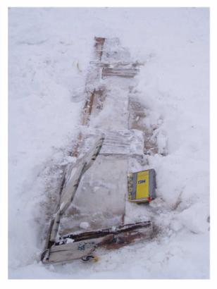
While
traveling between camp and the northern survey area, the remains of a small
wooden boat were observed on the crest of a small island (N 68.46092 W
98.52167) by Saul Aksalook (see Figure 7). The visible boat remains included only a short stem, the
foredeck and a 2.25m length of starboard planking and gunwale. A quick survey was conducted May
16. Snow was removed just enough
to reveal the extent of the surviving articulated structure. No other remains of the boat or
associated artifacts were apparent through the snow in the vicinity (Fig. 9).
The most visible part of the boat
was the foredeck, consisting of three planks 19mm (¾ in.) thick with a shallow
scallop in the aft edge of the aft plank.
These were standing vertically, still lodged between the gunwale and
planks of the starboard side.
The rabbetted stem was straight,
and extended only 45.0cm (17 ¾ in.) from the top, shaped as a tenon above deck
level and between gunwales, to a finished bottom. Its dimensions were 3.5cm (1 3/8 in.) sided, and 10.5cm (4
1/8 in.) molded. A galvanized iron
eye-bolt, 19mm (¾ in.) in diameter, passed through the approximate middle of
the stem, in which an almost entirely deteriorated fragment of a polypropylene
painter had survived.
Inside the planks were three
irregularly spaced “frames”. Each
was a different size, material, and dimension, and some or all may represent
repairs. One was 19mm (¾ in.)
plywood measuring about 15cm (6 in.) across while the others appeared to be
dimensional lumber: a “2x 4” and “1x 2”, measuring 3.9 x 9.0cm and 1.5 x 3.9cm,
respectively.
The planking, represented by a
single plank 17cm (6 5/8 in.) wide, was 2.0cm (3/4 in.) thick. The gunwale was flush to the inside of
the planking and measured 3.0cm wide.
Fastenings included screws of galvanized iron, and both galvanized and
cupreous nails.
None of the breaks in the wood were
fresh and there was no evidence of recent salvage or other disturbance.
Saul Aksalook, the principle
project guide and born in the area about 1944, guessed that the boat was
probably an old sealing skiff, although he had not seen one quite like it. He offered that sealing skiffs were
typically about 18 feet (5.5m) in length.
The frames and very short straight stem suggest a light flat-bottomed
construction.
Owing to the presence of
polypropylene rope, it is clear that the boat was in use within the last three
or four decades. Evidence of
repair and the unfamiliarity of the boat to the respondent suggest the boat may
have been built much earlier, perhaps the first half of 20th
century. As such it may warrant
classification as an “archaeological artifact”, although not according to the
Nunavut Archaeological and Palaeontological Sites Regulations because
abandonment clearly post dates the 50 years specified.
At
the end of field work for 2004, there is still no sign of any ship remains
underwater off Utjulik. The magnetic
anomalies investigated were evidently all geological in origin.
New sonar data confirms seabed
composition and form. It appears
to consist entirely of gravels and cobbles with occasional small boulders. Relief is very low. In this environment there is nothing to
mask the presence of cultural material standing proud of the seabed and no soft
sediments for burial. For these
reasons and thanks to the repeated overlapping of sonar images we can be
confident in the negative results of the sonar data.
The nature
of the seabed relates to the report that one or more of the ship’s masts were
visible after sinking. Only one of
the magnetometer targets was in water too deep for the top of the main mast on Erebus to have shown.
The minimal slope evident everywhere on the surveyed seabed suggests the
ship should not have settled with a list much more than would naturally be
indicated by the depth of its keel and hull deadrise. In the case of the Erebus, the angle of heel would not exceed 10 degrees, or an
insufficient amount to significantly reduce the height of the masts.
There is also good reason to expect
any shipwreck within the survey area to have maintained a three-dimensional
aspect. Other known saltwater
shipwrecks in Nunavut, the Breadalbane,
located in deep water 700km north of Utjulik, and James Knight’s ships, Albany and Discovery (1720), located in shallow water off Marble Island at a latitude
approximately the same distance south of Utjulik, are three-dimensional and
exhibit excellent levels of organic preservation. Both of these wreck sites have been protected from moving
ice damage by depth and protective landforms, respectively. Within the Utjulik survey areas, no
evidence of ice scour on the seabed has been encountered, which argues convincingly
for similar protection from moving ice.
The fact that the magnetometer data
have not led to the discovery of a shipwreck does not necessarily indicate that
there is no shipwreck within the area surveyed by magnetometer. In contrast to the flat, sonar-friendly
seabed, the local magnetic background is very “noisy” with considerable
potential of masking metal concentrations. It is also possible that local environmental conditions are
particularly poor with respect to iron preservation. Only negative sonar data can be taken with confidence to
indicate the absence of a shipwreck over substantial areas of the seabed off
Utjulik, especially given that substantive articulated remains might be
anticipated.
In the northern search area, about
80km2 of the seabed has been covered by side-scan and
forward-looking sonar. The area
that “best fits” with the historic record in this area clearly has no shipwreck
in it, however, this does not mean that an expanded search of the northern
search area, as may be defined by water depths and other factors, is not
warranted.
Following the 2004 season only
about the 1.38km2 of the southern search area have been surveyed by
sonar
and over 150km2 of seabed remains to be investigated. Based on past rates of survey by boat
this should take about four seasons to complete. However, both the accumulated archaeological data and oral
testimony seem to increasingly point to this area northeast of O’Reilly Island
as the most likely location of the wreck, making continued search efforts there
worthwhile.
Further information obtained in
2004 from Inuit sources indicated that the islet dubbed “skull islet”, after a
skull thought to be European was discovered there on the 1997 expedition, is
the location known as “Ook-soo-see-too”, where footprints of Franklin crewmen
were seen in the snow by contemporaries.
A tent site and optical prism were also found there in 2002. Approximately 8km to the east of
“Ook-soo-see-too”, on the Adelaide Peninsula near the entrance to Sherman Inlet,
a “large stick” was found approximately eight years ago by a hunter (now
deceased). This surface find has
been seen by Saul Aksalook from whose 2002 description it is apparent that the
“stick” may be a fragment of mast or other substantial spar. A one-day search for it was conducted
during the 2002 expedition, which was unsuccessful probably due to snow
cover. Another search in 2004 was
not attempted owing to similar snow conditions, but the presence of the
possible spar was independently corroborated by various informants, albeit with
second-hand knowledge. The
distribution of these finds along with other potentially ship-related
artifacts, including the spike with a broad arrow found in 1965, the copper,
belaying pin, barrel staves, and “other evidence of a nearby wreck” found in
1967, and the wood, copper sheet, and pot bottom found in 1997, seem to point
to a source within the southern part of Wilmot and Crampton Bay, to the north
and/or east of O’Reilly Island.
It is remarkable that finds apparently
related to one of Franklin’s ships are still being found along the shores of
this area. The validity of the
apparent distribution pattern should be tested with walking searches in the
summer months of local areas where historic artifacts, remains, or features
have not yet been located. These should focus on the western
shores of O’Reilly Island and those islands immediately to the north of it,
especially the one at the northern end of the chain where camp #2 was located
in 2004. In addition to the relocating
the supposed spar fragment, the mainland shores either side of the entrance to
Sherman Inlet should be searched, as should any parts of the island chain to
the north and east of skull Islet that have not been walked yet. Correlating the resulting pattern with
prevailing current and wind directions in the summer months should indicate the
high priority areas for further work with side-scan or forward-looking sonar.
Another method to reduce the area
covered by vessel-born sonar would be to begin with a contour-based survey of
shallower water immediately north of O’Reilly Island. There is no point in surveying water less than 30 ft. (9.1m)
because this approximates the height of the bulwarks on a bomb vessel. The priority should also be placed on surveying
water deep enough to be free of ice-impact. Determining if this boundary is deeper than 30 ft. by sonar,
and diver or ROV and defining this line around shoal waters within the search
area would help delimit the area more usefully covered in swaths. Establishing the basic bathymetry of
the search area will also help define the deeper limits of the search area
along the 130 ft. (40m) contour.
Archaeological data collected to
date off Utjulik remain incomplete with respect to testing the hypothesis that
one of Franklin’s ships sank in either the southern or northern search
areas. The debris found on land in
the vicinity of O’Reilly Island may suggest the presence of submerged wreckage
but it may be from the barge lost to the west of O’Reilly Island in 1926, or be
material that may have drifted in from other ships wrecked to the north. The potential remains for gathering
field data from land and underwater that will both assist further search
directed at a Franklin vessel, or reveal other submerged cultural
resources.