Mission to Utjulik
David C. Woodman
© David C. Woodman, 1998
There were a few worried faces as the Canadian Coast Guard ship Laurier crunched through a thin line of ice last summer. Not that the broken one-year floes posed much of a problem to the Laurier or her crew, as the icebreaker easily shoved the pans aside. The worry was on the face of my fellow members of the Franklin 150 expedition, for we required ice-free waters only ten miles to the south. The Laurier was to serve as our home and support the two survey launches crammed with sensitive electronics which we hoped to use to search for one of the most elusive wrecks in Canadian Arctic history.
In 1845 Sir John Franklin and his 128 crew had sailed into legend aboard their two ships, HMS Erebus and Terror. In search of the last piece of the centuries-old puzzle of the Northwest Passage, they entered the vast Arctic Archipelago and disappeared without a trace. Although one short note and a trail of skeletons and artifacts were later found by searchers, only the barest outline of what happened to the expedition emerged. The two ships had been beset in the pack ice near Cape Felix, King William Island, in September 1846, and had never managed to extricate themselves. The one preserved communication from the crew, known as the Victory Point record, informed later searchers that by April of 1848 twenty-four men (including Franklin) had died, and that the remainder had abandoned their ships to begin a doomed march to the south. There were no survivors.
Much of what we know about the Franklin disaster comes from the collected remembrances of the Inuit. The natives told that one of Franklin's ships sank quickly in deep water and expressed much regret that they consequently had obtained little from her in the form of valuable wood or iron. The other, however, had been found near a place called Utjulik - a name which was then given to the western coast of the Adelaide Peninsula - hundreds of miles south of where the ships had been abandoned. Even more fascinating were the details of a gangplank placed on the ice, recent deck sweepings, the tracks of three men and a dog on the shore, and the presence of the body of a white man inside. Since according to the surviving record the 1848 abandonment had been total, traditions of a single ship with a few survivors left open the possibility that the vessels had been remanned and that the final survivors might have left evidence with the ship that would help elucidate the mystery.
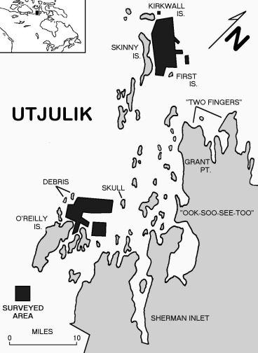
The wreck of the Utjulik ship has never been located although clues have emerged over the years. A decade after the disaster the explorer Charles Francis Hall was told by the Inuit that 'it was found by the Ootjoolik natives near O'Reilly Island, latitude 68 degrees 30 minutes north, longitude 99 degrees west." This was a somewhat confusing statement for O'Reilly Island is approximately thirty miles south of the position given by Hall. Hall described how his informants had pointed out the place where the wreck was found on a chart, noting that "it was very near O'Reilly Island, a little eastward of the north end of said island, between it and Wilmot and Crampton Bay." In this century there had been some physical corroboration of this description - in 1965 a geological team discovered a long iron bolt on Nail Island nearby, and two years later a Navy diving team discovered some debris ashore on the north coast of O'Reilly which they believed might indicate the presence of a wreck.
But there was another site. In 1879 an even more seemingly-definitive description of the location had been given by Puhtoorak, a hunter who claimed to have stood on the deck of the ship before it sank. According to him the ship "was frozen in the ice near an island about five miles due west of Grant Point." Puhtoorak told how the wreck had gone to the bottom so that the mastheads were still visible (until knocked over by the next winter's ice) and he remembered that before it sank the natives "had to walk out about three miles on smooth ice to reach the ship."
Of course the Inuit did not use terms like "miles" or "Grant Point." What the white men were told was that the ship was to the west of tikerqat - "two fingers," which later was identified as two narrow points (Grant being the southernmost) which stick out from the Adelaide Peninsula. Puhtoorak's description would place the wreck very near modern Kirkwall Island. Encouragingly, the Inuit name for Kirkwall was Umiartaliq - "ship island."
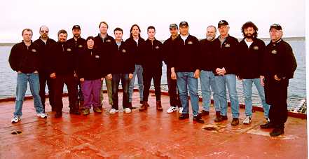
Armed with this information we had arrived in Cambridge Bay in hopes of using modern underwater search technology to confirm Inuit oral history. The expedition had been organized and financed by Eco-Nova Multimedia Corporation, and producers John Davis and Rick Haupt proved themselves to be experienced underwater filmmakers with a passion for the Franklin mystery. They had managed to assemble an impressive array of talent for the search, led by archaeologist Dr. Robert Grenier. Onboard the Laurier were representatives from Parks Canada, the Canadian Hydrographic Service, the Geological Survey of Canada, Dalhousie University and the Department of National Defence, each contributing vital expertise and equipment. Armed with differential positioning systems, sidescan sonars and magnetometers we hoped to be able to survey the ocean floor near both Grant Point and O'Reilly Island, and put the mystery to rest. As the ice-floes disappeared giving way to the low featureless outline of Kirkwall Island we started to appreciate just how large a task we had set ourselves.
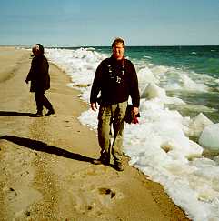
We had only twelve days and were well aware that the weather, even in the height of the short Arctic summer, would not co-operate and allow us to use all of them. After quickly setting up and testing the equipment on the launches and the shore station, we began a two-pronged assault on the mystery. Each day the Laurier's helicopter would take parties ashore to examine the surrounding small islets for artifacts or drift debris which might allow us to focus our search. Islands which appeared so small on the chart became dauntingly large when the shore parties were faced with walking around them into the ever-present arctic wind with sand and gravel slipping underfoot with every step. Every night the scientists would discuss the latest finds - interesting geological traces, surprising flora and fauna, or ancient tent-circles. Although there were no traces of Franklin-era debris there was always the hope that a spar or ship's block would be found half-buried in the sand of the next bay.
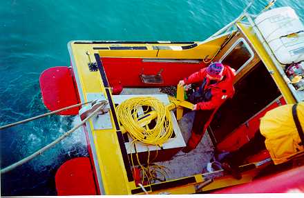
Meanwhile our two launches spent the long days of unending sunlight slowly patrolling along preplanned lines building a chart and hoping to find the “trace” which would signal success. The work was at once monotonous and demanding, but as each day passed another small box on the chart was shaded in as "searched." The areas of the chart which had been blank were now filled in with a grid of soundings, indicating that the area to the east of Kirkwall was a relatively flat plain between 20 and 40m deep, the exact depths needed to corroborate Puhtoorak's statement that after the strange ship sank her masthead was still visible above the surface. The lack of ice scours on the bottom was also encouraging for it indicated that no large masses of ice were forced into the area, leading us to hope that the wreck would have been unmolested beneath the surface ice which forms about 2m thick in that area.
After a week of fruitless search doubts were beginning to emerge, and the pull of the artifacts discovered at O'Reilly in the sixties was palpable. Excitement ran high when a helicopter trip to do a preliminary survey of O'Reilly resulted in the recovery of a small (2" x 2") piece of sheet copper with what appears to be tar adhering to one side, and a piece of yellow-painted wood with square bronze nails.
Although we had not completed our original search box, circumstances conspired to send us to the south. A technical problem with the helicopter meant that the Laurier would have to proceed through Simpson Strait nearer to Gjoa Haven to conduct a planned pilot exchange. This was followed by a diversion of the ship to the west to transfer fuel with the Henry Larsen, which had escorted the cruise vessel Hanseatic through heavy ice near where Franklin's ships had been beset over a century before. After a short but pleasant visit with the Larsen we were back at work, this time making for O'Reilly Island and the second search area.
By now we were beginning to consider that we may have been misled by the seemingly specific reference to Grant Point. It was pointed out that to the east of O'Reilly Island the entrance to Sherman Inlet also offered two points of land which could be considered "fingers." With only three search days left we were aware that we could not reproduce the scientific search we had conducted to the north. Hampered by worsening weather the two launches did manage to conduct a hydrographic survey and spot checks of what were determined to be the most likely areas. This revealed that the underwater profile at O’Reilly was much more complicated than that at Kirkwall. Every day brought more debris from the shore searches, much of it obviously of modern material but with some enigmatic pieces which would require later expert analysis.
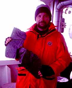
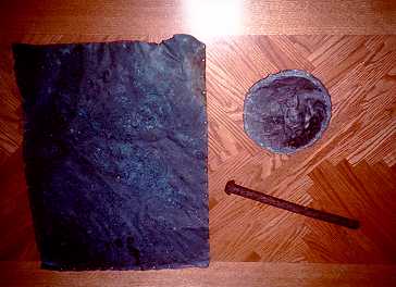
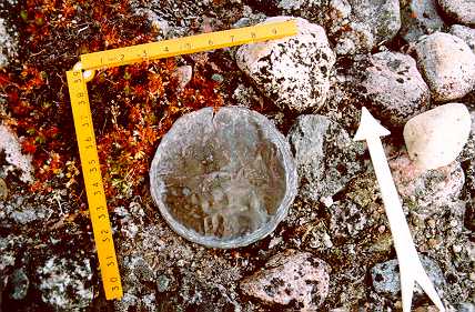
The most exciting things recovered were two sheets of copper, each about 24" square. One of these had apparently been crumpled by ice and had tar and oakum or horsehair on one side. Also recovered was a copper about 6" in diameter disk (later determined to be part of a "Britannia" coffee pot) and a long (9") iron spike or drift-bolt. All of these were found in an abandoned Inuit encampment on the highest point of an offlying islet, and later analysis would reveal that all were consistent with known examples from the mid-nineteenth century. When the recovered copper sheeting was compared with similar sheeting recovered from the Breadalbane (a Franklin search ship which sank in 1850) it was determined that the sheets had not been submerged in salt water for any appreciable time, lending support to the idea that they may have come from the ship before it sank, or from one of the recovered boats spoken of by the Inuit.
A further surprise awaited us as the analysis of some of our data progressed. On the last day of search a shore party had come across a weathered human skull which had been thought to be Inuit. As with all human remains found in the arctic it was left undisturbed, but detailed photographic analysis revealed that it may actually be of a Caucasian, and that the extent of weathering is consistent with other known Franklin remains investigated during the last few years. This immediately brought to mind Inuit remembrances of the tracks of hunting parties which were reported on shore near the wreck. If this skull actually was the remains of a Franklin crewman this would be the first direct evidence supporting this testimony, and a valuable clue as to the location of the wreck.
In the end we succumbed to the same problem faced by Franklin and his men - too much geography and too little time. As we dismantled the launches and packed all of the electronic gear we could take pride in the fact that we had managed to survey about 100 square kilometres of uncharted ocean floor, making our own small contribution towards the geographical exploration which had inspired Franklin and his men one hundred and fifty years ago. Although we had not found the Utjuliq wreck we had meticulously searched a large area which could now be removed from consideration. Everything we had discovered tended to confirm the validity of oral history concerning the wreck - water depths, debris patterns, and the recovered artifacts all confirmed our belief that Franklin’s ship lay hidden nearby. The wreck remains stubbornly hidden after one hundred and fifty years, waiting patiently for the next search party, jealously guarding evidence which may help to resolve the most enduring mystery of the Arctic.