Printable Campus Map

Printable Map and Accessible Description

Print our campus map on standard letter-size paper (8.5 x 11 inches) or larger. A full text description of the map, including buildings, parking areas, and accessibility features, is also provided.

Campus Map graphic rendering with legend

Open the Printable Map
The map will load directly in your browser, where you can easily select File > Print.

Campus Map Description

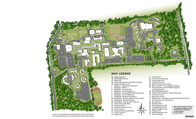
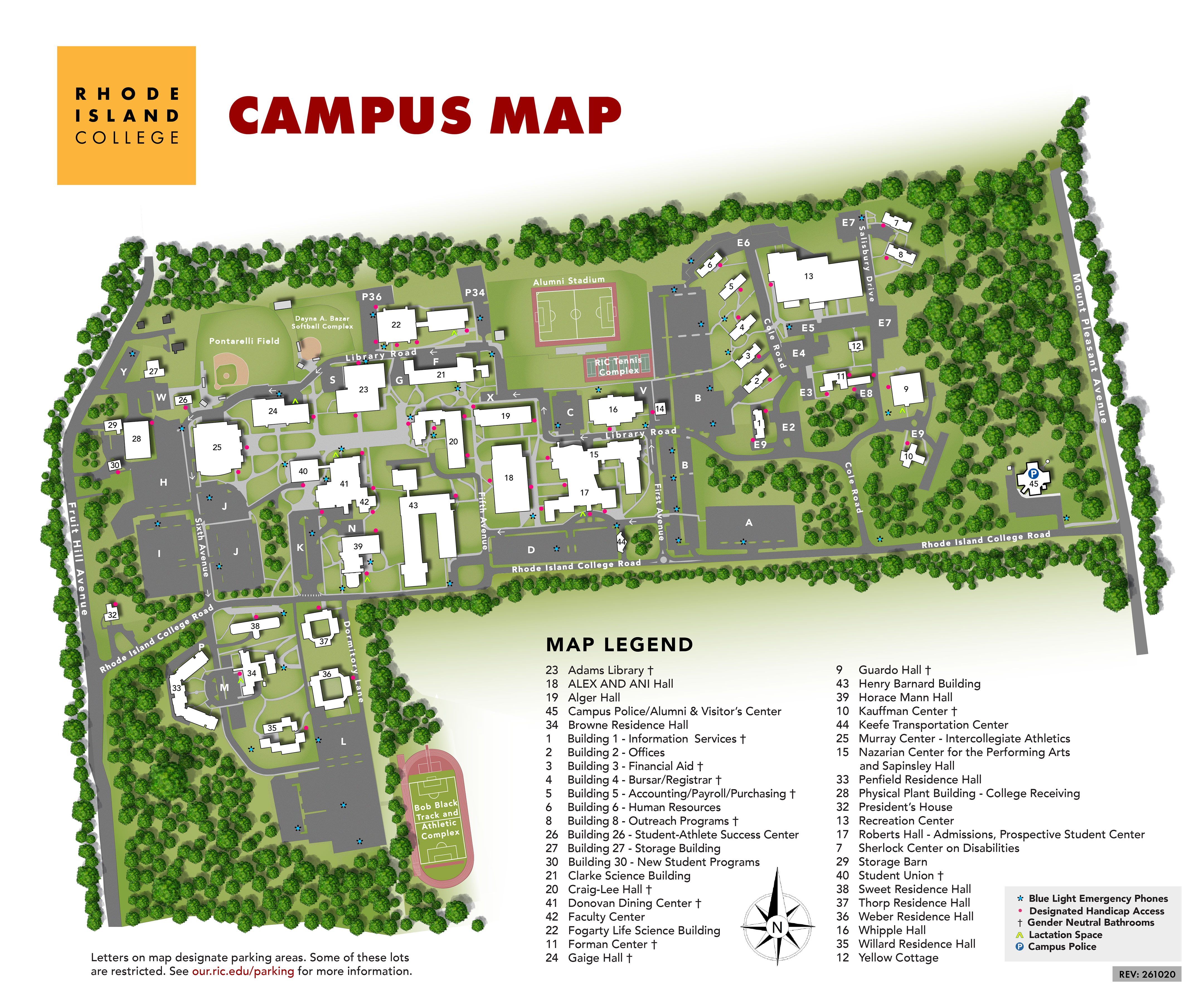
This illustrated map shows the Rhode Island College campus from above, with north at the top. Buildings are marked with numbers and parking areas with letters. Building names are listed below, followed by a description of where buildings and parking areas are located.

The main campus stretches east to west, with a residential area extending to the southwest. Fruit Hill Avenue runs along the western edge of campus and Mount Pleasant Avenue runs along the eastern edge. Rhode Island College Road runs along the southern side of the main campus, connecting Fruit Hill Avenue to Mount Pleasant Avenue. Library Road runs east to west through the northern part of campus. Sixth Avenue, Fifth Avenue, and First Avenue run north to south between Library Road and Rhode Island College Road. On the east side of campus, Cole Road and Salisbury Drive connect Library Road and Rhode Island College Road. Dormitory Lane runs south from Rhode Island College Road through the residence hall area.

  • West campus: Murray Center (25), Physical Plant Building (28), Storage Barn (29), Building 26, Building 27, and Building 30. Pontarelli Field and the Dayna A. Bazar Softball Complex are in the northwest corner. The President’s House (32) is south of Rhode Island College Road near Fruit Hill Avenue.
  • Central campus: Most academic buildings, including Adams Library (23), Gaige Hall (24), Clarke Science Building (21), Fogarty Life Science Building (22), Alger Hall (19), Craig-Lee Hall (20), Student Union (40), Donovan Dining Center (41), Faculty Center (42), Henry Barnard Building (43), Horace Mann Hall (39), ALEX AND ANI Hall (18), Roberts Hall (17), Nazarian Center for the Performing Arts and Sapinsley Hall (15), and Whipple Hall (16). Keefe Transportation Center (44) is on Rhode Island College Road near Roberts Hall.
  • North central campus: Alumni Stadium and the RIC Tennis Complex, north of Library Road.
  • East campus: Buildings 1 through 6, the Recreation Center (13), Sherlock Center on Disabilities (7), Building 8, Forman Center (11), Yellow Cottage (12), Guardo Hall (9), and Kauffman Center (10). Campus Police and the Alumni & Visitor’s Center (45) are in the southeast, near Mount Pleasant Avenue.
  • Southwest residential area: Sweet (38), Thorp (37), Weber (36), Penfield (33), Browne (34), and Willard (35) residence halls, south of Rhode Island College Road. The Bob Black Track and Athletic Complex is at the southern end of this area.

A cross symbol (†) marks buildings with gender neutral bathrooms.

  • 1 – Building 1 – Information Services †
  • 2 – Building 2 – Offices
  • 3 – Building 3 – Financial Aid †
  • 4 – Building 4 – Bursar/Registrar †
  • 5 – Building 5 – Accounting/Payroll/Purchasing †
  • 6 – Building 6 – Human Resources
  • 7 – Sherlock Center on Disabilities
  • 8 – Building 8 – Outreach Programs †
  • 9 – Guardo Hall †
  • 10 – Kauffman Center †
  • 11 – Forman Center †
  • 12 – Yellow Cottage
  • 13 – Recreation Center
  • 15 – Nazarian Center for the Performing Arts and Sapinsley Hall
  • 16 – Whipple Hall
  • 17 – Roberts Hall – Admissions, Prospective Student Center
  • 18 – ALEX AND ANI Hall
  • 19 – Alger Hall
  • 20 – Craig-Lee Hall †
  • 21 – Clarke Science Building
  • 22 – Fogarty Life Science Building
  • 23 – Adams Library †
  • 24 – Gaige Hall †
  • 25 – Murray Center – Intercollegiate Athletics
  • 26 – Building 26 – Student-Athlete Success Center
  • 27 – Building 27 – Storage Building
  • 28 – Physical Plant Building – College Receiving
  • 29 – Storage Barn
  • 30 – Building 30 – New Student Programs
  • 32 – President’s House
  • 33 – Penfield Residence Hall
  • 34 – Browne Residence Hall
  • 35 – Willard Residence Hall
  • 36 – Weber Residence Hall
  • 37 – Thorp Residence Hall
  • 38 – Sweet Residence Hall
  • 39 – Horace Mann Hall
  • 40 – Student Union †
  • 41 – Donovan Dining Center †
  • 42 – Faculty Center
  • 43 – Henry Barnard Building
  • 44 – Keefe Transportation Center
  • 45 – Campus Police/Alumni & Visitor’s Center

Letters on the map designate parking areas. Some of these lots are restricted. Get more detailed parking information.

  • West campus: Lots H, I, J, W, and Y, near the Murray Center and Physical Plant Building.
  • Central campus: Lots C, F, G, K, N, S, V, X, P34, and P36, near the academic buildings. Lot D is along Rhode Island College Road near Roberts Hall.
  • East campus: Lots A and B, east of First Avenue, and Lots E2 through E9, near the east campus buildings.
  • Southwest residential area: Lots L, M, and P, near the residence halls.

The map also uses symbols to mark the following features throughout campus:

  • Blue light emergency phones are located throughout campus, including along roads, in parking lots, and near building entrances.
  • Designated handicap access points are marked at building entrances across campus.
  • Lactation spaces are marked at Fogarty Life Science Building (22), Gaige Hall (24), Donovan Dining Center (41), Roberts Hall (17), Horace Mann Hall (39), Browne Residence Hall (34), and Guardo Hall (9).
  • Campus Police is located at building 45, in the southeast corner of campus near Mount Pleasant Avenue.