Coastal Geography – A Study in History
Geography is not about memorizing the names of states, it's a field of science dedicated to the study of everything on the earth and in the earth – the lands, features, inhabitants and geological phenomena. "Geography is the history of the planet,” says RIC Adjunct Instructor of Geography Jennifer Bonin.
For five summers, Bonin has taught a course on coastal geography, providing students with the history of Rhode Island’s coastal regions.
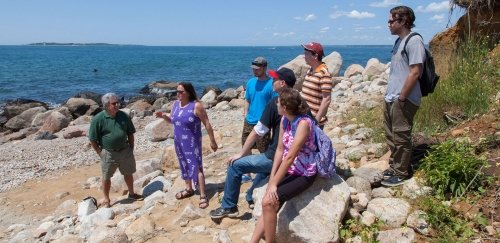
Her first class is held at Napatree Point in Westerly, the western-most part of Rhode Island. Located at the end of a mile-and-a-half-long stretch of beach, not even the locals tend to venture out that far.
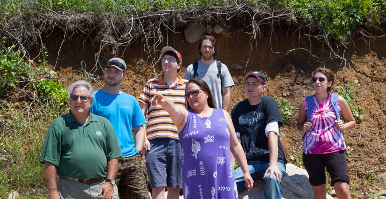
At 9:30 a.m., a van drops Bonin and her six students off in the touristy center of town. Quickly they leave behind the teeming throngs, climb a steep dune and head down to the other side toward the beach.
There, the sand is strewn with seaweed, crinkled and blackened like discarded film. Skeletal remains of sea creatures also litter the beach. Here, a crab claw like broken pliers; there, a cracked shell, the flesh eaten away from the inside. It is a graveyard scattered with the remains of the once was.
After a half-hour walk, Bonin and her students finally arrive at Napatree Point. They settle down on the rocks and Bonin begins her 45-minute lecture on coastal geography and glacial processes, including how the rocks they sit upon came to be there.
“Geologists call them drop stones,” she says. “They are left by glaciers. As glaciers move forward, they drag with them deposits, which they drop on the coastline.”
She likens glaciers to a snowplow. “When a snowplow pushes snow in a lot, it also takes with it sand, rocks and other debris, then piles it all into a corner,” she says. “When the snow melts, the sand, rock and other debris are left behind. The deposits didn’t originate there. They were dragged from far distances by the plow and dropped there. In the same way, all of these rocks you see on the coastline originated much farther north of here.”
Erosion is a natural occurrence here, she goes on, because Napatree Point is a sandbar composed of more sand than soil and its shoreline is daily worked upon by the waves. “The coastline used to extend much further offshore,” she says, “but the waves have steadily cut away at it year after year. In geologic time, this entire coastline will eventually disappear.”
Then she points behind her to a 12-foot ledge that looks as if a big chunk of land had been bitten from it. “Now the source of the erosion happening here is inland,” she says. “The ocean no longer reaches this point. But when it rains the inland runoff eats away at the ledge.”
Following her lecture, Bonin tells her students to go off on their own to find examples of the topics she has talked about and to try and formulate their homework assignments.
“I could do a PowerPoint presentation on glaciers and geologic formations, but it wouldn’t have the impact of seeing it for themselves,” she says.
It is now midday and the sun is high. Waves rush forward in foaming surf, lapping at the rocks. Bonin gazes out over the ocean where fishing boats move across the glass-like surface on an expedition for meat of the sea.
“The land changes every day,” she reflects. “You may not notice the changes right away, but when you come down to Napatree Point and see the erosion and see the coastline where houses once stood, you begin to understand how much geography is tied into history.”
This summer, her students will visit four other coastal sites: the Mohegan Bluffs on the southern shore of Block Island, Woods Hole Oceanographic Institution in Massachusetts, the Boston Harbor Islands and the USS Constitution.
On each excursion, Bonin will also talk about how tourism affects the coastline. “Tourism is good and bad for the coast,” she said. “It boosts the economy of the local area but it also brings in pleasure crafts and pollution.”
By the end of the day, as the students walk the mile-and-a-half trek back to town, Bonin continues to find teachable moments. She points to the coastal foliage as “a great nesting area for birds.” She notes the clear ocean water at Napatree Point and compares it to the seaweed-infested water further up the coast, explaining the geologic reasons for it. Bonin is a repository of information and her listeners hang on to every word.
Jennifer Bonin, a 2004 graduate of Rhode Island College, also teaches RIC courses in disaster management and GIS (the geographic information system). She is a GIS specialist and disaster analyst, experienced in providing mapping of Federal Emergency Management Agency flood insurance zones, meteorological research and analyses. She also volunteers at the Providence Emergency Management Agency and Office of Homeland Security – a central command and control facility that carries out emergency management during threatened, or actual, natural disasters, as well as acts of terrorism or manmade disasters. Bonin has received commendations from the mayor of Providence for her work with the agency.